![](/images/other/stat-length.png)
![Randonnée Marche La Bresse - La Bresse Vologne et les lacs (2) - Photo](https://media.geolcdn.com/t/1900/400/ext.pjpeg?maxdim=2&url=https%3A%2F%2Fstatic1.geolcdn.com%2Fsiteimages%2Fupload%2Ffiles%2F1553511878bg_sport_marche.png)
La Bresse Vologne et les lacs (2)
DanielROLLET
Utilisateur
![Longueur](/images/other/stat-length.png)
Longueur
21 km
![Altitude max](https://static1.geolcdn.com/siteimages/upload/files/1508320355ic_sort_altitude_max_24dp.png)
Altitude max
1352 m
![Dénivelé positif](https://static1.geolcdn.com/siteimages/upload/files/1508320355ic_sort_den_pos_24dp.png)
Dénivelé positif
1156 m
![Km-Effort](/images/other/stat-length.png)
Km-Effort
36 km
![Altitude min](https://static1.geolcdn.com/siteimages/upload/files/1508320355ic_sort_altitude_min_24dp.png)
Altitude min
801 m
![Dénivelé négatif](https://static1.geolcdn.com/siteimages/upload/files/1508320355ic_sort_den_neg_24dp.png)
Dénivelé négatif
1160 m
![Boucle](https://static1.geolcdn.com/siteimages/upload/files/16400158638029165_repeat_loop_refresh_sync_direction_icon.png)
Boucle
Oui
Date de création :
2015-07-27 00:00:00.0
Dernière modification :
2015-07-27 00:00:00.0
![Marche](https://static1.geolcdn.com/sitytour/trail-icons/101.png)
7h21
Difficulté : Très difficile
![Scannez ce code QR pour ouvrir la randonnée dans l'application SityTrail](https://capi.geolives.com/qq0zvz2zws4bq2lad0pu/sitytour/trails/450842/qr.png?size=200)
Application GPS de randonnée GRATUITE
À propos
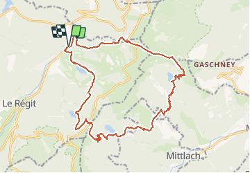
Randonnée Marche de 21 km à découvrir à Grand Est, Vosges, La Bresse. Cette randonnée est proposée par DanielROLLET.
Description
Départ parking espace nordique route de VOlogne. Le Hohneck - Schiessrothried - Fiscboedele - AltenWeiher - Blanchemer - Lac de la Lande - retour parking
Localisation
Pays :
France
Région :
Grand Est
Département/Province :
Vosges
Commune :
La Bresse
Localité :
Unknown
Départ:(Dec)
Départ:(UTM)
349016 ; 5322715 (32U) N.
Commentaires
Randonnées à proximité
![Randonnée Marche La Bresse - 2023-04-16 Marche Abri Lac de Blanchemer vers Lac de Lispach - Photo](https://media.geolcdn.com/t/375/260/20b642e6-a3a8-4790-bc8e-b2ad298c0408.jpg&format=jpg&maxdim=2)
![Marche Marche](https://static1.geolcdn.com/sitytour/trail-icons/101.png)
2023-04-16 Marche Abri Lac de Blanchemer vers Lac de Lispach
Marche
Très difficile
(1)
La Bresse,
Grand Est,
Vosges,
France
![](/images/other/stat-length.png)
23 km | 36 km-effort
8h 4min
![](https://static1.geolcdn.com/siteimages/upload/files/16400158638029165_repeat_loop_refresh_sync_direction_icon.png)
Non
![Randonnée Marche La Bresse - 2023-04-15 Marche Abri Collet de Etang vers Abri Lac de Blanchemer - Photo](https://media.geolcdn.com/t/375/260/f5705708-8e73-435e-a1e8-28d1d0c03215.jpg&format=jpg&maxdim=2)
![Marche Marche](https://static1.geolcdn.com/sitytour/trail-icons/101.png)
2023-04-15 Marche Abri Collet de Etang vers Abri Lac de Blanchemer
Marche
Moyen
(1)
La Bresse,
Grand Est,
Vosges,
France
![](/images/other/stat-length.png)
22 km | 35 km-effort
7h 51min
![](https://static1.geolcdn.com/siteimages/upload/files/16400158638029165_repeat_loop_refresh_sync_direction_icon.png)
Non
![Randonnée Marche Le Valtin - Les Rochers des Hirschsteine - Lac Vert - Photo](https://media.geolcdn.com/t/375/260/4177d9e5-d8bc-4dac-ac45-c42f01ca30d3.jpg&format=jpg&maxdim=2)
![Marche Marche](https://static1.geolcdn.com/sitytour/trail-icons/101.png)
Les Rochers des Hirschsteine - Lac Vert
Marche
Difficile
(2)
Le Valtin,
Grand Est,
Vosges,
France
![](/images/other/stat-length.png)
14,4 km | 22 km-effort
5h 2min
![](https://static1.geolcdn.com/siteimages/upload/files/16400158638029165_repeat_loop_refresh_sync_direction_icon.png)
Oui
![Randonnée Marche La Bresse - Kastelberg des pierres, des lacs, des panoramas magnifiques - Photo](https://media.geolcdn.com/t/375/260/cada329c-fae7-4d3f-815e-38ed5d6ce361.jpg&format=jpg&maxdim=2)
![Marche Marche](https://static1.geolcdn.com/sitytour/trail-icons/101.png)
Kastelberg des pierres, des lacs, des panoramas magnifiques
Marche
Difficile
(1)
La Bresse,
Grand Est,
Vosges,
France
![](/images/other/stat-length.png)
15,1 km | 26 km-effort
6h 11min
![](https://static1.geolcdn.com/siteimages/upload/files/16400158638029165_repeat_loop_refresh_sync_direction_icon.png)
Oui
![Randonnée Marche Le Valtin - Col de la Schlucht - Photo](https://media.geolcdn.com/t/375/260/5b598871-c43c-4378-92fe-f06bddb4af29.jpg&format=jpg&maxdim=2)
![Marche Marche](https://static1.geolcdn.com/sitytour/trail-icons/101.png)
Col de la Schlucht
Marche
Très facile
(1)
Le Valtin,
Grand Est,
Vosges,
France
![](/images/other/stat-length.png)
3,5 km | 5,2 km-effort
1h 17min
![](https://static1.geolcdn.com/siteimages/upload/files/16400158638029165_repeat_loop_refresh_sync_direction_icon.png)
Oui
![Randonnée Marche Le Valtin - Le Sentier des Roches - Photo](https://media.geolcdn.com/t/375/260/f2737479-0e9e-43ec-9b66-c9706dc8ef91.jpg&format=jpg&maxdim=2)
![Marche Marche](https://static1.geolcdn.com/sitytour/trail-icons/101.png)
Le Sentier des Roches
Marche
Difficile
(2)
Le Valtin,
Grand Est,
Vosges,
France
![](/images/other/stat-length.png)
20 km | 34 km-effort
7h 43min
![](https://static1.geolcdn.com/siteimages/upload/files/16400158638029165_repeat_loop_refresh_sync_direction_icon.png)
Oui
![Randonnée Marche La Bresse - Lac de Lispach et sentier Dielaine - Photo](https://media.geolcdn.com/t/375/260/b54731ea-6209-4cff-b7c0-af5225a4f3ae.jpg&format=jpg&maxdim=2)
![Marche Marche](https://static1.geolcdn.com/sitytour/trail-icons/101.png)
Lac de Lispach et sentier Dielaine
Marche
Moyen
(1)
La Bresse,
Grand Est,
Vosges,
France
![](/images/other/stat-length.png)
9,7 km | 14,9 km-effort
2h 30min
![](https://static1.geolcdn.com/siteimages/upload/files/16400158638029165_repeat_loop_refresh_sync_direction_icon.png)
Oui
![Randonnée Marche Stosswihr - Tour du belvedere avec le passage sur les crêtes - Photo](https://media.geolcdn.com/t/375/260/5b3c85c1-2643-45e9-9769-80e100e05dda.jpg&format=jpg&maxdim=2)
![Marche Marche](https://static1.geolcdn.com/sitytour/trail-icons/101.png)
Tour du belvedere avec le passage sur les crêtes
Marche
Très facile
(3)
Stosswihr,
Grand Est,
Haut-Rhin,
France
![](/images/other/stat-length.png)
8,5 km | 0 m-effort
2h 28min
![](https://static1.geolcdn.com/siteimages/upload/files/16400158638029165_repeat_loop_refresh_sync_direction_icon.png)
Oui
![Marche Marche](https://static1.geolcdn.com/sitytour/trail-icons/101.png)
Les 5 lacs autour du Hohneck
Marche
Très difficile
(1)
La Bresse,
Grand Est,
Vosges,
France
![](/images/other/stat-length.png)
21 km | 36 km-effort
7h 21min
![](https://static1.geolcdn.com/siteimages/upload/files/16400158638029165_repeat_loop_refresh_sync_direction_icon.png)
Oui